Creating Photos with Location & Maps Using Just an iPhone
Turning small discoveries hidden in everyday scenery into something tangible, rather than just consuming them as mere data, is an extremely effective way to foster intellectual curiosity. In my household, my children use an iPhone to photograph flowers found by the roadside, add information to those photos, and print them as postcards.
By not only saving them as ordinary photos, but also adding records of “when" and “where" those flowers were blooming, a single picture transforms into a meaningful “botanical survey record." As a mechanism to support this activity, I decided to build a custom tool that can be completed using only standard features.
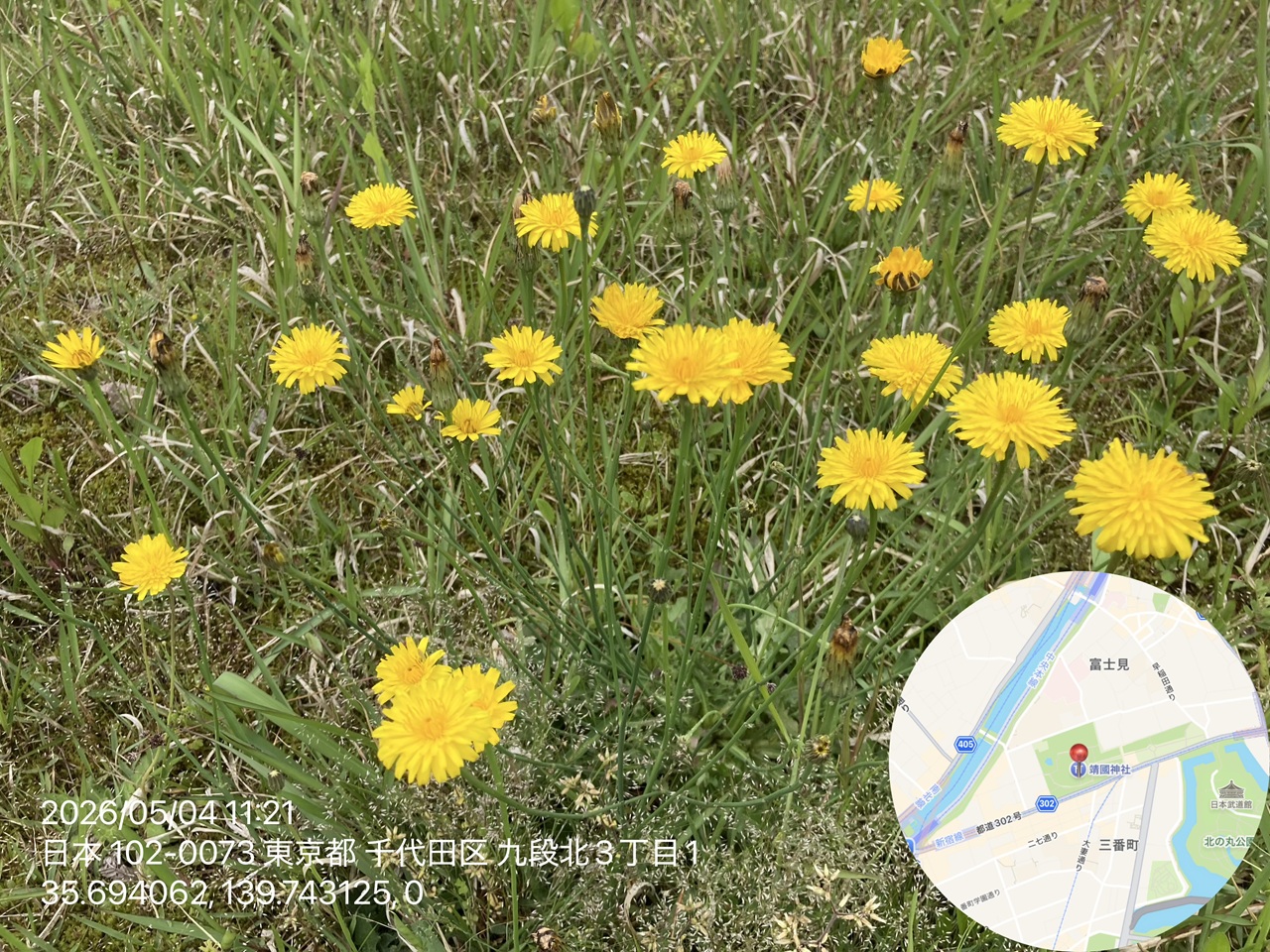 *The location information is dummy data.
Automating Records Using Location Information
The objective this time is to establish a workflow using the iOS “Shortcuts" app to batch-synthesize “date and time taken," “detailed address," “coordinates (latitude, longitude, altitude)," and “a map with a location indicator" onto multiple selected photos.
To increase the accuracy of post-survey research using field guides, it is essential to accurately preserve the context at the time of shooting. However, manually editing this information is not practical. Therefore, by building a system that automatically extracts the EXIF information (metadata) held by photos and reconstructs it into a visual layout, we aim to create an environment where children can concentrate on the essential activities of “investigation and discovery."
What This Shortcut Can Do
This shortcut is designed to meet the following target metrics, assuming it will be printed as a postcard:
- Batch Loop Processing: Automatically processes multiple selected photos one by one
- Automatic Layout Optimization: Automatically converts photos taken in portrait orientation to landscape (rotated 90 degrees)
- Detailed Metadata Superimposition of 7 Items: Places 7 variables—"Capture Date," “Region," “Postal Code," “Address," “Latitude," “Longitude," and “Altitude"—onto the photo in a layout that ensures visibility
- Generation of Map with Location Display: Overlays a map centered on the shooting location cropped into an “oval" shape.
We independently implemented a “shooting location pin (📍)" which is not displayed in standard actions, enhancing visual accuracy.
This has established an output infrastructure for “botanical survey records" that completes entirely within the iPhone without the need for additional third-party apps.
Installation and Execution Procedure
This shortcut can be installed using the following steps:
- Installation: Add the shortcut to your iPhone from the iCloud link below.
- Preparation for Execution: When running for the first time, a dialog asking for permission to retrieve maps and location information will appear. Please run it from within the “Shortcuts" app itself rather than an icon on the home screen. Although I haven’t tested it, if you set it to “Always Allow," the dialog will likely not appear.
- How to Use: Launch the shortcut and select the photos you want to synthesize from your library. Once processing is complete, a new image combining the location information and map will be saved to your Photos app.

 https://www.icloud.com/shortcuts/8825b6e71426404c87c0d909fe4...
Please note that depending on the shooting environment, location information (EXIF data) may not be included in a photo. In such cases, a safety feature is implemented where a popup notification appears and the relevant image is skipped.
Conclusion
To support children’s exploratory activities, I created a tool for synthesizing location information into photos using the standard iPhone “Shortcuts" app. This makes it possible to instantly create recording cards by batch-synthesizing the date and time, detailed address, latitude and longitude, altitude, and a map with a location pin onto multiple photos.
I am sharing this mechanism as an iCloud shared link. I hope this shortcut will be helpful to those who similarly value “keeping records" or enjoy exploratory activities with their children.